Basic Orientation in Valencia, Spain
 Valencia
is often described as "charming to get lost in". It certainly
is, with its atmospheric old streets, but the charm goes away quickly
when you suddenly need to get somewhere fast or you are hungry.
Orientation in central Valencia can be more challenging than in
many other cities. Spending 15 minutes learning this page pays off
later.
Valencia
is often described as "charming to get lost in". It certainly
is, with its atmospheric old streets, but the charm goes away quickly
when you suddenly need to get somewhere fast or you are hungry.
Orientation in central Valencia can be more challenging than in
many other cities. Spending 15 minutes learning this page pays off
later.
This page is very important. Take your time to read and understand it and you will find your time in Valencia much more productive - you will see more, lose less time and have more options. It is also a lot easier to use this website once you know which areas are being referred to.
Valencia is is generally very logical and often symmetrical. Apart from the centre - that part can be very confusing and needs special attention.
The Centre
![]()
The centre is where most things to see are.
The centre of Valencia is clearly defined. It is enclosed in a hexagon. The six corners are:
1. Puente de Real bridge
2. green Glorieta square ending with a marble arch
3. Train station and Bullring
4. Libraby (old Hospital) - a cross-like Rennaisance
building
5. IVAM Modern Art Museum
6. no landmark
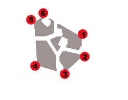
You will find it very obvious when you go beyond the boundaries of the hexagon - you will either have to cross a large street (Guillem de Castro on the West or Colon on the East) or the Turia river-garden. So go ahead and get lost in the centre, it is a great experience. And unavoidable.
The main landmarks within the centre are 4 main gorgeous squares where you will find a good half of Valencia's sights:
7. Plaza de Ayntamento
8. Plaza de la Reina
9. Plaza de la Virgen
10. Glorieta - shady green
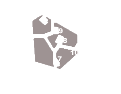
These squares make for spectacular sightseeing.
On the north side of Plaza Ayuntamento (7) there is a fork. The right San Vicente Martir, a gorgeous alley, will lead you to Plaza de la Reina (8). If you turn right from here, you wil be connected to Glorieta Square (10) by Calle la Paz - a long straight landmark street in Valencia - remember it.
Coming back to Plaza de la Reina (8) for the moment. Just behind it is Plaza de la Virgen (9) - the main historic square of Valencia.
The centre is thus split roughly into 4 quarters and a core in
the middle. In reality, only the core, the top left quarter and
the bottom right quarter are worth seeing - the first two constituting
the Old Town landscape of Carmen (read below) and the remaining
quarter being the more upmarket, done-up business and administrative
district with stunning architecture. The other two quarters have
almost no sights, nor are they visually special areas.

Carmen
![]()
Carmen is the most referred-to part of the Centre, being the epcentre of central cultural and leisure activity.
It is in ancient medieval district with charming corners and lots of sightseeing, esp closer to the core of the centre. However, Carmen is insane on a map and you will do well getting your bearings here.
Officially, Barrio del Carmen is enclosed within the square of
9 . Plaza de la Virgen (see above)
12. Torres de Quart (Wall gates)
5. IVAM Modern Art Museum (see above)
11. Torres de Serranos (Wall gates)
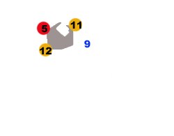
...With Plaza de Carmen (marked green) in the depth of the district.
Practically though, the atmosphere of the barrio has spread beyond
those boundaries and when you hear "Carmen" it will mean
something like this >>>>
This is important to keep in mind when reading this website.
13. Mercado Central (Central Market)
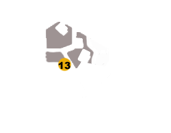
It is important to know the main arteries for getting around Carmen, marked on the maps - they can save you when you are lost and confused. Here they are:
C/ San Vicente Martir - connecting Pz Ayuntemento (7) and Pz de la Reina (8)
C/ Serranos - connectins Pz de la Virgen (9) and Torres Serranos (11)
C/ Caballeros, Pz Tossal, C/ Quart - in this order, the main artery from Pz de la Virgen (9) to Torres Quart (12)
C/ Bolseria - connecting Mecado Central (13) with Pz Tossal
Pz Tossal is the central junction in Carmen, joining C/ Caballeros from Pz de la Virgen (9), C/ Quart from Torres Quart (12) and C/ Bolseria from mercado Central (13)
Pz Tossal also has two main arteries of the inner Carmen shooting off - C/ Baja and C/ Alta, going North to Pz del Carmen (marked green on the map). They are not marked on the maps since they are of secondary importance, but they come in very useful if you explore inner Carmen, esp at night.
Canovas
![]()
To the South-East of the Centro lies a typical XIX century Spanish expansion of L'Example. The large chunk of this area closest to the river is known as Canovas, for being around Pz de Canovas. Canovas is a booming leisure district on weekends - with a large nightlife and the most cosmopolitan (and one of the largest) selection of restaurants. While this district is quite pretty for a walk, there isn't, however, any sightseeing.
The restaurants and nightlife concentrate immediately around Pz de Canovas (green circle on the map) and to the South of its main artery - wide alley of gran Via marques del Turia. The closer to the river you get, the more dense the leisure becomes.

Juan Llorens
![]()
Like Canovas (see above), Juan Llorens also appears only in the restaurants and nightlife listings. It is a smaller and more dense cluster of weekend leisure situated almost perfectly symmetrical to Canovas, on the other side of the Centro, behind the major city artery Gran Via Fernando de Catolico

North of the River
![]()
North of the river only the Eastern half is of interest, the part between the sea and the centre. It is quite simple to work out
Two mega-arteries go to the sea - Avenida del Puerto (2) ends at the America's Cup Port and Avenida Blasco Ibanez (3) goes almost all the way to the beach. Avenida de Aragon (1) connects the top of Av. Puerto with Av. Blasco Ibanez. There are two more avenues parallel to and below Av. Aragon - Cardenal Benlloch and Manuel Candela

Avenida del Puerto (2) is only of marginal interest for some of its restaurants and hotels, if you are staying in the area.
Aragon and Blasco Ibanez (see above) are the student districts of Valencia, with lots of restaurants, live music and student nightlife. Aragon is also home to Mestalla football stadium. The name Zona Blasco Ibanez refers not to the whole avenue (3) but rather to the section two thirds down, below Manuel Candela, on both sides, where most of the stuff is.

CAS - City of Arts and Sciences
![]()
This area is of interest for 2 reasons, First, you have to see the CAS at no excuse. Second, the area between CAS (marked red on the map) and Av. Puerto (2 - see above) has become an upmarket cluster of hotels, restaurants and shopping. You may well end up staying here, along the main arteries of Av. Francia or Av. Baleares

Beach / Port Area
![]()
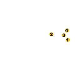
The coastline of Valencia starts with the America's Cup Port (1) right at the end of Avenida del Puerto (2) and carries on north in 4km of a beachline.
Right before it is the maritime district of Cabanyal (3) with some good sight-seeing, restaurants and architecture in its Southern part. The main street here is Calle de la Reina (4)
References to the Port / Beach area throughout this site usually mean America's Cup Port, Southern Cabanyal or the stretch of the beach closest to the port.
Maps
Right now you can check out the interactive which will help you to get acquainted with the layout of the city
Once in the city, you can get paper maps:
Official map + map of bus routes - available free in Tourist Offices
Corte Ingles maps - free maps distributed by the Corte Ingles megastores throughout the city, e.g. hostels, shops, etc. Take care with this one! - it is turned 90 degrees so you may get confused about North and West. The sea should be on the East of the city, i.e. right side of the map.
Tourist maps and resources - available to buy in souvenir shops and newspaper vendors.